Hypack MAX components
- Brand:
- Type:
- Price: RMB
- Promotion: RMB ( 0 Customers Bought)


The plan to build the line: a straight line or curved line;
A two-dimensional or three-dimensional measuring line;
Establishment of the drawing page file:
For Hyplot drawing; establish matrix file:
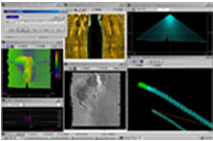
Display real-time coverage; integrated water depth data;using depth information in real-time rendering seabed;
Measurement of the background documents:
BSP grid file (from Maptech);
Microstation DGN file;
The Ortho-Photo file;
S-57 vector;
C-Map vector;
NIMA vector format (VPF); coordinate tool:
The three parameter and seven parameter coordinate transformation; different types of grid, including: NAD-27and NAD-83; coordinate transformation, the grid conversion;
Measurement: support the single beam, multi beam, multitransducer system;
Support for different types of GPS;
RTK real time tide; separation and screen the operator(need special cards); real-time marking;
Data processing: RTK: tide, tide gauge, artificial tide,Harmonic;
Velocity correction:
Single beam data interactive graphics editing; data screening:
Mapping Mapper; screening; screening based on 3D model;
Cross sectional and earthwork calculation: before and afterdredging;
Hypack method for complex section;
The USAEC method; the actual proportion of print and drawing section; different time section;
Drawing: the output from the support of the printer; support the coordinate grid, track line, water depth, line, targetcontour;
Three dimensional model:
By comparing the calculated earthwork; to the plane of theearth (reservoir); earthwork calculation according to thechannel;
The two measurements (coastal erosion): results of 2D or 3D display; different models show; the establishment of DXF contour line file;
CAD file import / export to CAD:
The DXF and DGN files into Hypack; DXF output and DGNoutput file; water depth, the track line, line, target;