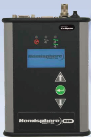
R330 beacon machine adopts Hemisphere GNSS Eclipse ™ platform and our latest patented GNSS technology.
R330 beacon through the use of such as RTK, L-bandDGNSS (VBS/HP/XP/G2) and beacon and other correctionmethod provides accurate positioning function.
R330 GNSS receiver in any high precision requirements of marine or terrestrial applications, have good work performance. The base station is configured as a L1GNSS, 10Hz and the original data, the function of a base station can be upgraded to L1/L2 GNSS, 20Hz, RTK, L-band and beacon, compatible with GNSS antenna R330including A21 ™, A31 ™, A42 ™, A43 ® and A52 ™.
R330 ™ GNSS beacon receiver new will exceed itsprevious products, and provides a friendly user experience.It has a Hemisphere GNSS exclusive Eclipse SureTrack ™ technology, so as to ensure that the receiver in the satellitecarrier model for flow station tracked, which makes the operator can be modified without base station informationto work.
A key advantage of R330 GNSS beacon receiver:
RTK, GNSS, L1/L2 GNSS, SBAS, high precision positioningbeacon and L-band
• SureTrack technology to improve the performance of RTK
• in harsh environments less RTK flying spot
Jump detection technology, better week brings more rapidreacquisition and more powerful solution
• state indicating lamp and a menu system ensures that the R330 is easy to use and configure
Provide mechanical control and guide the best, up to 20Hz data update rate
• 50 km RTK baseline
The USB flash memory device, can be used with standardfor data recording
R330 GNSS beacon receiver performance parameters:
Receiving type: GNSS L1&L2, RTK carrier phase
Can receive the signal: GPS, GLONASS and BeiDou 4
Number of channels: 270
SBAS: 3 channel parallel tracking, tracking
Update rate: Standard 10Hz, 20Hz optional
Timing (1PPS) accuracy: 20 ns
Cold start: < 60 seconds (no ephemeris and clock)
Warm start: < 30 seconds (a typical calendar or clock)
Hot start: < 10 seconds (a typical calendar, clock and position)
Maximum speed: 1850 km / h (999 miles / hour)
The highest elevation of 18288 meters (60000 feet):
Differential type: SBAS, independent, external RTCM, RTK,L-band (VBS/HP/XP/G2) 3
Positioning accuracy: 2 meters
RMS (67%) horizontal and vertical
Single point, no SA: 1.2 m 2.5 m
SBAS (WAAS): 20.3 m 0.6 m
L-band DGPS: 0.3 m 0.6 m
Differential GPS: 0.3 m 0.6 m
L-band L1/L2: 0.15 m 0.3 M
RTK: 10 mm+ 1 ppm 20 mm+ 2 ppm


